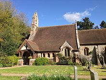
Halstead, Kent
| Halstead | |
|---|---|
 Church Road | |
Location within Kent | |
| Population | 1,607 (2011 Census) |
| District | |
| Shire county | |
| Region | |
| Country | England |
| Sovereign state | United Kingdom |
| Post town | Sevenoaks |
| Postcode district | TN14 |
| Police | Kent |
| Fire | Kent |
| Ambulance | South East Coast |
| UK Parliament | |
Halstead is a village and civil parish in the Sevenoaks District of Kent, England. It is located 4.7 miles south east of Orpington and & 6.1 miles north west of Sevenoaks, adjacent to the Kent border with Greater London. The population of the civil parish at the 2011 census was 1,607.[1]

The name Halstead is derived from the Old English hald (refuge, shelter) and stede (site, place), meaning 'safe place' or 'place of refuge'. The parish church is dedicated to St Margaret. Halstead Community Primary School is located in the village.
Botanist and photographer Anne Atkins lived since 1841 to her death at Halstead Place, where she is buried. Author Edith Nesbit spent some of her adolescence in Halstead during the 1870s and her book The Railway Children is thought to be based on her time living in a house, Halstead Hall, whose garden is about a mile and a half from the railway line.
The parish is adjacent to Fort Halstead, a government defence research centre that is thought to have developed Britain's first atomic bomb.
Sports Clubs
[edit]- Chelsfield Football club
- Halstead Cricket Club
- Halstead Netball club
- Orpington & District Amateur Boxing Club
Transport
[edit]Rail
[edit]The nearest National Rail station to Halstead is Knockholt, located 1.4 miles away.
Buses
[edit]
Halstead is served by London Buses routes R5 and R10 which provide connections to Orpington, Cudham and Knockholt.[citation needed][2][3]
See also
[edit]References
[edit]- ^ "Civil Parish population 2011". Neighbourhood Statistics. Office for National Statistics. Retrieved 18 September 2016.
- ^ Transport for London. "R5 bus route". Transport for London. Retrieved 17 August 2023.
- ^ Transport for London. "R10 bus route". Transport for London. Retrieved 17 August 2023.
- Hasted, Edward - "The History of Kent" pp319–322 (1788, reprinted 1972).
- Kitchener, Geoffrey - "Halstead in Kent - An Historical Guide" (1978).
External links
[edit]![]() Media related to Halstead, Kent at Wikimedia Commons
Media related to Halstead, Kent at Wikimedia Commons
51°20′N 0°8′E / 51.333°N 0.133°E


